


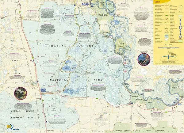
The Hattah-Kulkyne National Park contains one of Australia's most unique wetland eco-systems. World renowned for its intricate lakes system and wide variety of flora and fauna, the Hattah-Kulkyne National Park has until now, never been shown in detail on a commercially available map.
The Hattah - Kulkyne map and guide fills the breach, providing a wealth of information on the park and its surrounds in an easy-to-read map. The map is designed not only for use at the park, but can also be used as a planning tool. The comprehensive list of telephone numbers, book references and the incisive text will make your next trip to the Hattah-Kulkyne National Park even more enjoyable and informative.
Designed primarily for the camper, bushwalker, fisherman, four-wheel-driver or day-tripper, the map contains the latest data available.
Accompanying the map is a generous amount of text and photography highlighting the park's history, flora and fauna, and conservation. There are also sections covering local information, web links, further reading, and local tour operators. The map folds to a handy pocket size of 215 x 99 mm and is printed on a hard wearing paper suitable for the rigours of the mallee outback.


 with Professional Cleaning Kit")


